2 layers116.8 × 30 mm
Type d
google/mozc-devices
Circuit diagrams and firmware source code for Gboard DIY keyboards
14 parts3kApache-2.0

 kumahide/radiosim1
国土地理院DEMで地形断面・フレネル第1ゾーン遮蔽率・回折損(Bullington/ITU-R P.526)・リンクバジェットを即時計算する、業務無線の回線見通しスクリーニング用デスクトップツール(Windows/Python・MIT)
Field carrier is an open-source printed circuit board by kumahide, from the kumahide/radiosim repository on GitHub, published under the MIT licence. It is a 2-layer board of 55 × 45.8 mm with 14 parts on 20 nets, routed with 70 tracks and 88 vias.
Its parts include 6 resistors, 3 diodes, 3 connectors and 2 capacitors. It belongs with the radio and wireless boards and the ESP32 and RISC-V boards of this library.


📣 RadioSim Pro の開発は 3.9.1 で終わります。後継は別のアプリ「RadioSim Link」です。 3.x の次に予定していた変更(判定の
REVIEW・成果物 CSV の末尾 2 列・ライス K の見直し)は、4.0 ではなく Link 1.0 で入ります。3.9.x では、Link 1.0 を正式に公開するまで、致命的な不具合だけを直します。3.x で保存したプロジェクトファイル(.rsproj)は Link 1.0 で開けます(3.9.x と同じ計算方式で計算します)。Development of RadioSim Pro ends with 3.9.1. Its successor is a separate app, "RadioSim Link". The changes planned after 3.x (the
REVIEWverdict, two appended CSV columns, and the Rice K review) arrive in Link 1.0 instead of a 4.0. Until Link 1.0 is officially released, 3.9.x receives fixes for critical bugs only. Project files (.rsproj) saved by 3.x open in Link 1.0, calculated with the same method as 3.9.x.
国土地理院 DEM(数値標高モデル)を自動で取得し、地形断面・回折損・フレネル第1ゾーン遮蔽率・リンクバジェットを計算する Windows デスクトップアプリです。 送信点と受信点の座標・アンテナ高・周波数を入れるだけで、その回線が通りそうかを数秒で判定します。現地調査に出る前のスクリーニングに用途を絞ったツールで、無料・MIT ライセンス・インストール不要の Windows バイナリも配布しています。
組み込みの標高データと背景地図は国土地理院タイルのみです。日本国外で使うには、利用者が宣言ファイルで外部の DEM ソースと背景地図ソースを追加してください。組み込みの航空写真での確認は国土地理院タイル固定のため日本国内でしか使えませんが、帳票に貼る経路地図は地図ウィンドウで選んだ背景地図ソースに従うため、宣言した外部ソースを選べば日本国外でも使えます(3.6〜)。(詳細は下記 FAQ「日本国外の回線には使えますか?」)
A desktop propagation simulator for land mobile radio links: terrain profiles, diffraction loss, Fresnel zone clearance and link budgets, computed from GSI DEM (Geospatial Information Authority of Japan) elevation tiles fetched automatically. The only built-in elevation source and background map are GSI, but you can add external DEM and background map sources via declaration files to work outside Japan; the built-in aerial-photo confirmation stays fixed to GSI tiles and remains Japan-only, but the map embedded in reports follows whichever background source is selected in the map window, so it works outside Japan too once you add an external source (from 3.6). English documentation: docs/manual_en.md (users) and docs/developer_en.md (developers).
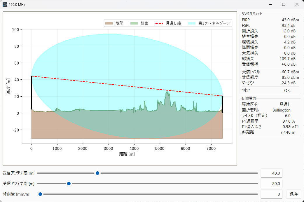
使わないほうがよい用途: 回線設計の最終判断。組み込みの国土地理院 DEM の水平解像度は 5〜10m で、回折損の実質精度は ±5〜15 dB 程度です。⚠️ この範囲は、複数の障害物が重なる経路には当てはまりません——合成損失は実測とも基準実装とも突き合わせていません(下記)。
🔴 回折損は過大にも過小にも出ることがあり、どの経路で信頼できるかを事前に見分ける方法がありません。 3.0 で回折モデルを Bullington 等価ナイフエッジ(ITU-R P.526 §4.5.1) に替え、①山越えで数百〜数千 dB になる発散と、②植生高やアンテナ高を 1m 動かすだけで 84 dB 跳ぶ不連続を解消しました。ただし外れる可能性そのものが消えたわけではありません。①合成損失は実測とも基準実装とも突き合わせていません。②離れた 2 つ以上の尾根がある経路では小さめに出ます(この手法の既知の性質です)。③地形の解像度を上げると回折損が増えます(「低」の 20m 間隔 →「高」の画素の縁ごとで最大 +407%)。④平滑地球の球面回折の項を持たないため、低いアンテナで見通し距離を超える長い平坦路(海上など)では過小になりえます。⚠️ 起伏の大きさでも F1 遮蔽率でも、どの経路が外れるかは判定できません。⚠️ F1 遮蔽率は表示上 100% で頭打ちなので、率の側からは異常に気づけません。
🛡 自衛策 — **「回折モデル」を
Singleに切り替えて計算し直し、2 つの値を見比べてください。**大きく食い違う経路では既定(Bullington)の値を信用しないでください。⚠️ これは正しさを決める手段ではなく、結果がモデルの選び方にどれだけ依存しているかの診断です(差が小さくても正しさは保証されません)。Singleは複数障害物の合成損失を表現せず標準の補正項も掛けないので Bullington より小さく出ますが、それが真の値に近いという意味ではありません。🔴 Diffraction loss can come out too high or too low, and no advance test tells you which paths are safe. Version 3.0 replaced the model with the Bullington equivalent knife edge (ITU-R P.526 4.5.1), removing both the divergence that produced hundreds to thousands of dB over mountains and a discontinuity that moved the result by 84 dB when vegetation or antenna height changed by 1 m. Multi-obstacle results have not been checked against measurements or a reference implementation; the method reads low where two or more ridges are well separated; a finer terrain resolution still raises the diffraction loss (up to +407% from the 20 m "low" step to the pixel-edge "high" step); and the spherical-earth term is not included, so long flat paths with low antennas beyond the radio horizon can read low. Neither relief nor Fresnel blockage predicts which paths are affected. Fresnel blockage is capped at 100% wherever it is shown, so the percentage will not warn you either. Mitigation: re-run with the Diffraction Model set to
Singleand compare — where the two differ substantially, do not trust the default.
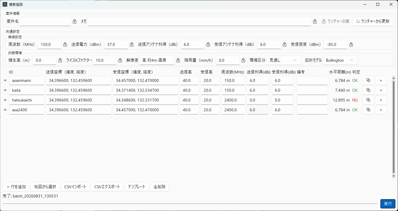
.rsproj) — 座標・パラメータ・案件情報をまとめて保存し、続きから再開<言語コード>.json を置くと言語メニューに現れます(置き場はインストール形態で異なり、インストーラ版は %APPDATA%\RadioSim\lang、ポータブル版はアプリと同じフォルダの lang)。訳が無いキーは英語のまま出るので、全部を訳さなくても壊れません(非公式な訳という位置づけで、追加した言語では画面の見切れを保証しません)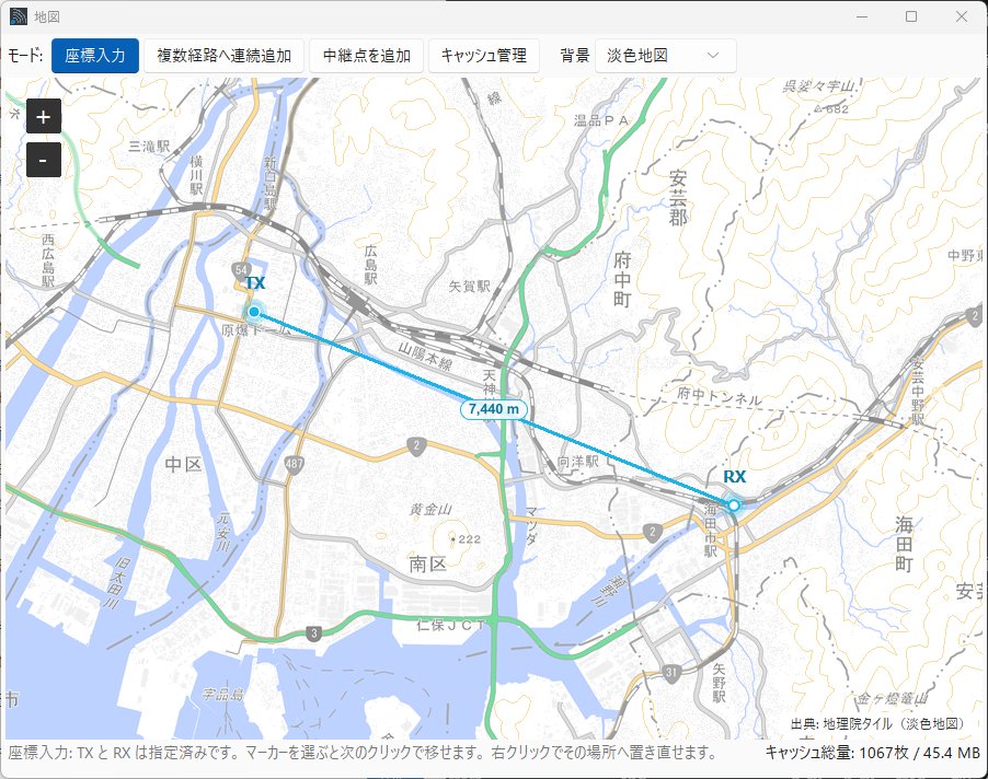
| 項目 | 準拠・方式 |
|---|---|
| 回折損 | Fresnel-Kirchhoff 単一エッジ(ITU-R P.526 のナイフエッジ式)/Bullington 等価ナイフエッジ(ITU-R P.526 §4.5.1・標準の補正項つき。⚠️ P.452 の完全法が足す球面回折の項は持ちません) |
| 自由空間伝搬損失 | FSPL(球面波) |
| 地球曲率補正 | 標準大気 K = 4/3 |
| フレネルゾーン | 第 1 フレネル半径と地形・植生の交差から遮蔽率を算出 |
| 植生減衰 | 見通し線への侵入深さモデル(植生高は経路一律) |
| 環境損失 | 市街地 / 郊外 / 農村 / 見通し の 4 区分 |
| 降雨減衰 | ITU-R P.838-3 |
| 大気(ガス)減衰 | ITU-R P.676-13 Annex 2 簡易式 |
| 標高データ | 国土地理院 標高タイル(5m / 10m メッシュ・自動取得+ローカルキャッシュ) |
| 形式 | 内容 |
|---|---|
| HTML レポート | 印刷確定レポート。ブラウザの Ctrl+P だけで PDF 化できます(追加ソフト不要)。経路 1 本の詳細(report.html)は A4 縦 1 枚に収まります。複数経路の台帳や全ページ連結版は、行数・経路数に応じて複数ページになります |
| KML | 地形・見通し線・フレネルゾーン・遮蔽区間の 3D 表示。Google Earth でそのまま開けます |
| PNG | 地形断面グラフ |
| CSV | 全経路・全条件の数値と、経路上の地形断面データ |
| JSON | 入力パラメータ一式(再現用) |
インストーラ版(推奨): Releases から RadioSimPro-Setup-<版>.exe をダウンロードして実行(管理者権限不要)。設定・キャッシュ・結果は OS 標準の場所(%APPDATA%/%LOCALAPPDATA%/ドキュメント)へ保存されます。インストーラ版は 1 台に 1 つで、別の版を入れると置き換わります(3.7 以降は版を比べ、古い版へ戻すときは確認します。詳細は docs/manual_ja.md)。
ポータブル版: 同じく Releases から RadioSimPro-<版>.zip をダウンロードし、ZIP を展開して RadioSimPro.exe をダブルクリック。設定・キャッシュ・結果は展開したフォルダの中に作られ、USB メモリ等で持ち運べます。複数の版を並べて使うときはこちら(版ごとに別のフォルダへ展開すれば、データごと分かれます)。
署名なし EXE のため SmartScreen 警告が出る場合があります。「詳細情報」→「実行」をクリックしてください。
⚠️ インストーラがウィザードを 1 画面も出さずに「エラー 4551: アプリケーション制御ポリシーによってこのファイルがブロックされました」で中止される場合、これは SmartScreen ではなく Windows のアプリケーション制御による実行拒否で、続行するボタンがありません(Windows 11 の Smart App Control が有効な PC で起こります。有効かどうかは〔Windows セキュリティ〕→〔アプリとブラウザーの制御〕で確認できます)。**その場合は上のポータブル版をお使いください。**ただしポータブル版の
RadioSimPro.exeも同じ判定の対象なので、必ず起動できるとは限りません(止められた場合は組織の管理者にご相談ください)。詳細は docs/manual_ja.md を参照してください。
Python 3.12 以降が必要です。
git clone https://github.com/kumahide/radiosim.git
cd radiosim
python -m pip install -r requirements.txt
python main.py不要です。標高タイルは公開されており、アプリが必要な範囲だけを自動で取得します。取得したタイルはローカルにキャッシュされるので、同じ経路を何度計算しても再取得は起きません。
限定的に使えます。組み込みで登録されている標高データは国土地理院のタイルだけですが、利用者が設定フォルダに宣言ファイルを置くと、外部の標高タイル(XYZ PNG)を DEM ソースとして追加できます(3.4〜)。改善するのはカバー範囲であって精度ではありません。
地図ウィンドウの背景地図も、同じように宣言ファイルで追加できます(3.5〜)。足さない場合の背景地図(淡色地図・航空写真)は国土地理院タイルなので、日本国外では何も描かれません。帳票に載る経路地図の画像は、地図ウィンドウで最後に選んだ背景地図ソースに従います(3.6〜)ので、宣言した外部ソースを選べば日本国外でも描かれます。組み込みの航空写真だけは国土地理院タイル固定のままで、日本国外の現地確認には使えません。
MIT ライセンスの無料ソフトです。商用利用も可能です(LICENSE)。
動きます。メニューからプロキシを設定できるほか、企業内 CA を使う環境向けに OS の証明書ストアを参照する経路も用意しています。
| 読みたいもの | 場所 |
|---|---|
| 使い方(Windows バイナリ版の利用者向け) | docs/manual_ja.md |
| 開発者向け(構成・計算モデル詳細・アーキテクチャ) | docs/developer_ja.md |
| 変更履歴 | CHANGELOG.md |
| English — user manual | docs/manual_en.md |
| English — for developers | docs/developer_en.md |
ℹ️ 上のリンク先は開発中の最新(main)の文書で、まだ公開していない版の説明を含むことがあります。お使いの版の説明は、配布物に同梱の文書(アプリのヘルプ →「ドキュメントを開く」)か、その版のタグ(例:
3.7)の文書をご覧ください。The links above point to the latest documents on main, which may describe a version not yet released. For the version you use, read the documents bundled with it (Help → Open Documentation in the app) or the documents at that version's tag (e.g.
3.7).
© 2026 BearValley AI Craftworks. All rights reserved.
| Qty | Value | Footprint | References |
|---|---|---|---|
| 4 | 330 | Resistor_THT:R_Axial_DIN0204_L3.6mm_D1.6mm_P5.08mm_Horizontal | R1, R2, R3, R4 |
| 3 | OSRGHC3132A | field_carrier:LED_D3.0mm-3_Horizontal_O2.54mm_Z2.0mm | D1, D2, D3 |
| 2 | 100nF | Capacitor_THT:C_Disc_D3.0mm_W1.6mm_P2.50mm | C1, C2 |
| 2 | 1k | Resistor_THT:R_Axial_DIN0204_L3.6mm_D1.6mm_P5.08mm_Horizontal | R5, R6 |
| 1 | E220_EV2 | field_carrier:E220_EV2 | J3 |
| 1 | XIAO_ESP32C6 | field_carrier:XIAO_ESP32C6_FaceDown | J1 |
| 1 | ログ_UART0 | Connector_PinHeader_2.54mm:PinHeader_1x03_P2.54mm_Vertical | J4 |
google/mozc-devices
Circuit diagrams and firmware source code for Gboard DIY keyboards


hackclub/OnBoard
💡 Join 1,000 teenagers and make your first PCB with a $100 grant!


Twotoz/C5VRX
Ultra-minimal, zero-CPU 5.8 GHz analog FPV video receiver using ESP32-C5 Wi-Fi 6 PHY MODEM_DIAG, BitScrambler WBFM demodulation & resistor DAC CVBS


It measures 55 × 45.8 mm and has 2 copper layers, 1.6 mm thick.
14 parts. The full list of its parts is on this page, with links to each part's symbol and footprint where PCBKit's library has them.
From the kumahide/radiosim repository on GitHub, at the commit this page was made from: the board is apps/field/pcb/field_carrier.kicad_pcb and its schematic apps/field/pcb/field_carrier.kicad_sch. PCBKit opens the board in the browser, with nothing to install.
Its repository publishes it under the MIT licence: you may reuse it on that licence's terms (keep the author's notice, and for a copyleft licence share your changes alike).